Sub4Sub network gives free YouTube subscribers

Supervised Classification in ArcGIS | LULC Mapping using GIS |7StarTech95

In this video we describe how to do supervised classification using gis software. How to make different classes
Supervised Classification in ArcGIS | LULC Mapping using GIS |7StarTech
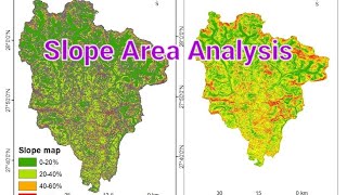
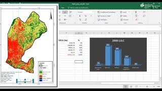
Supervised classification uses the spectral signatures obtained from training samples to classify an image. With the assistance of the Image Classification toolbar, you can easily create training samples to represent the classes you want to extract.
Our Patreon ID is here please donate us
/ 7startech95
Thanks for Watching...
Please like and share video AND
SUBSCRIBE our channel...
Follow us on facebook page...
/ 7startech95
Contact us at:
[email protected]
#LULC, #supervisedclassification,#7startech95,


Recommended