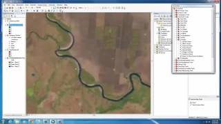
Supervised Image Classification in ArcGIS Desktop - ArcMap

In this screencast, you will use a Landsat image with supervised classification method to create a land cover map.
For this lab, you will use a Multispectral Landsat Level 1 image which can be downloaded from the USGS website: http://landsatlook.usgs.gov/ (Links to an external site.)Links to an external site.
You are welcome to download a Level 1 Dataset for anywhere in the world. If you want you can use the dataset that I used for the lab.
You are welcome to download a Level 1 Dataset for anywhere in the world. If you want you can use the dataset that I used for the lab.
Landsat Image: https://www.dropbox.com/s/8lgprvmbqrt... (Links to an external site.)Links to an external site.
Study Area (AOI): https://www.dropbox.com/s/ujhb61mcy3d... (Links to an external site.)Links to an external site.