Get YouTube subscribers that watch and like your videos

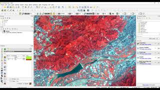
Supervised Image Classification with QGIS

Learn remote sensing in QGIS with this supervised image classification tutorial. This tutorial teaches you how to perform supervised image classification on Landsat 9 data using the QGIS semiautomatic classification plugin to create labels (regions of interest) with which you can train several different classification algorithms.
Full QGIS Remote Sensing Course: https://geospatialschool.com/courses/...
Stepbystep instructions: https://opensourceoptions.com/blog/su...


Recommended