The BEST Automated Drone Photogrammetry App! - UgCS

In today's video, I'm diving deep into the world of drone flight planning using the remarkable mission planning software, UgCS. We'll take an indepth look at how you can create an automated flight mission for your drone, execute a facade capture, and examine the generated data all without the need for manual image capturing.
Check out UgCS here: https://bit.ly/3BV9ftE
Sample Data:
Fry's Electronic Store: https://bit.ly/429flRQ
Condo Building: https://bit.ly/3q0gTjI
Data Download: https://drive.google.com/drive/folder...
—
► Join us on Pilot Byte! Our platform provides current and aspiring drone operators with information and resources to promote growth and development in the drone industry: https://www.pilotbyte.com
► Subscribe to my channel here: / dylangorman
—
My Camera Equipment!
Canon R5: https://amzn.to/36YsAP1
Canon 2470 2.8L: https://amzn.to/2S2KVCK
Rode Microphone: https://amzn.to/3pfokiM
Drone: https://amzn.to/3x9GHLW
__
Follow me online!
LinkedIn: / dylang099961101
Instagram: / dylang_1
—
Chapters
00:00 Intro
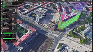
01:38 What Is UgCS?
02:22 Mission PrePlanning In Google Earth Pro
05:12 Fully Mission Planning Guide
07:44 Vertical Mission Planning Guide
10:08 Mission Sync From UgCS to DJI Pilot 2
12:07 Automated Data Capture
13:32 Photogrammetry Model Review
16:53 Free Data Access
17:11 Closing Statements