It was never so easy to get YouTube subscribers

The New York City Evolution Animation

LEARN MORE: https://www.myleszhang.org/heregrows...
VIEW FILM AS INTERACTIVE MAP: https://storymaps.arcgis.com/stories/...
MUSIC: "The Language of Cities" by Maserati
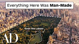
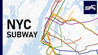
This animation illustrates the development of NYC’s street grid and infrastructure systems from 1609 to the presentday, using georeferenced road network data and historic maps. The resulting short film presents a series of “cartographic snapshots” of NYC’s builtup urban area at intervals of every 2030 years history.
#HereGrowsNewYork


Recommended