The White Bluffs at Hanford Reach - Columbia River Free Flowing Stretch
2 Minute Geology visits the White Bluffs just north of Richland, WA on the Hanford Reach National Monument. The last freeflowing stretch of the Columbia River.
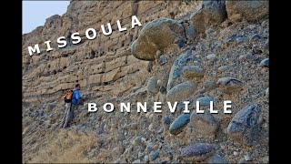
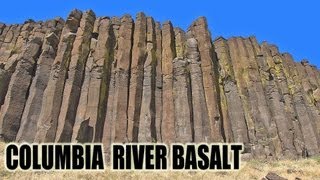
The White Bluffs are on the east side of the river. Three hundred feet of soft, sedimentary layers. And another two hundred feet of that sediment below river level. And below that, more than two miles of lava rock, the Columbia River Basalt flows.
On the other side of the river here is the Hanford Site. Back in 1943, restricted due to the topsecret Manhattan Project. Since 2000, this side of the river has been opened up and available for recreation. Here, on this side of the river, the White Bluffs are composed of the Ringold Formation. A series of sedimentary layers deposited between eight and three million years ago. This is back during a time when the ancestral Snake and Columbia Rivers were bringing sediment into this area. Sluggish streams eventually becoming broad lake deposits. And there's a rich fossil record in Ringold Formation. Prehistoric animals including horses and camel.
But, there is a small section of the White Bluffs that looks very different. These sediments are rhythmically deposited. They're Ice Age flood deposits that were deposited in a preexisting channel that was cut into the Ringold. This is Lake Lewis time during the Ice Age floods. Just a few thousand years ago. Not millions of years ago.
On the surface of the White Bluffs, you'd probably be surprised at how many exotic rocks are littering the surface. Those are icerafted erratics. Even more evidence of the Ice Age floods sweeping down into Lake Lewis which existed in the Pasco Basin.
Visit the HUGEfloods.com YouTube Channel for more "Geology Videos": / hugefloods