Tornadoes
Animation of supercell storms and tornadoes formation in Tornado Alley.
Full text:
Tornadoes arise from a specific type of thunderstorms. So, to investigate how tornadoes develop, it's important to first understand how thunderstorms develop.
Warm air rises during a normal thunderstorm. When the air cools and reaches a certain temperature limit, part of the water vapor condenses. Higher in the atmosphere, the condensed water vapor mixes with the drier surrounding air. As a result, the water vapor evaporates again, so that the cloud cannot temporarily grow vertically, but it does ensure that the surrounding air becomes more humid. New, warm, moist air that rises will therefore only condense higher in the atmosphere. As the water vapor cools, the air around it gets warmer, caused by the release of latent heat, allowing the cloud to rise further. This can create a very large cloud. Ice particles collide aloft, which can cause an electric charge. This electrical charge is released during a thunderstorm.
The large amount of precipitation in most cases causes cold air to descend. This is called a downdraft. The cold air prevents the warm air from entering the cloud, cutting off the cloud from the fuel it needs, which is warm moist air.
This is different for a multicell storm cloud: There is a big difference in wind speed and wind direction at other altitudes. This is called wind shear. Wind speeds are much higher aloft. This causes the storm cloud to move. Warm, moist air can rise from the front of the thundercloud, allowing the thundercloud to continue to develop. You will see a new cell emerge at the front. That is why this storm cloud is also called a multicell storm cloud: new cells are constantly being created. Under the storm cloud there is a very strong downdraft. Very strong wind gusts can form on the front between the cold and warm air. The temperature may also drop sharply temporarily in areas where there is a cold downdraft.
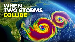
With a multicell storm cloud, there is very strong wind shear and the air can spin around a horizontal axis. Compare it to a pen that you place in the palm of your left hand. Put your right hand on top of the pen. Pull your left hand while you push your right hand away from you. The pen will now rotate. In this way, the air can also rotate. This is called a mesocyclone. When this happens, it is called a supercell storm cloud. This causes a tornado in about 15% of the supercell storm clouds. Conversely, most tornadoes arise from supercell storm clouds.
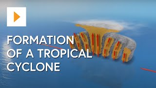
Tornadoes are common in the middle of the US, because different air flows converge here. The rocky mountains block winds from the west, allowing cold air to pass over the Great Plains from the north and forming a front with the warm, humid air from the south. This creates low pressure areas. The warm moist air is forced by the cold air to ascend, causing rain showers. High in the atmosphere, the strong jet stream provides the necessary wind shear, creating mesocyclones and eventueally supercell thunderstorms
The upward airflow then tilts the mesocyclone, creating rotating air around a vertical axis. Air is now drawn upwards at a high rate. The mesocyclone is still in the cloud. An extremely strong downwind can push the mesocyclone more to the earth's surface. Due to the strong updraft, the air pressure under the mesocyclone drops very quickly, causing the mesocyclone to drop: a funnel is created under the cloud.
Under the right conditions, there may be an interaction between the rear flank downdraft and the forward flank downdraft. The downdraft is therefore extremely important for the development of very strong tornadoes. Another possibility for the development of tornadoes is that rotating upward airflow is already present on the Earth's surface, causing the mesocyclone to move toward the Earth's surface and create a tornado.
Cold air cuts off the tornado from the warm, moist air. Because the tornado now narrows, the tornado becomes longer. This vertical extension causes the air to spin faster.
Because the supply of warm air is blocked, the tornado will often become weaker. The shape changes from a vertical air column to a looser air column, as if a rope falls from the cloud. After that, the tornado will dissipate. When the downdraft is hot and humid, the tornado can develop longer, so the tornado takes longer to dissipate.
The strong jet stream also takes the storm to the northeast, where new tornadoes sometimes arise. This area is often called Tornado Alley because of the common occurrence of tornadoes; an area around the Great Plains. Tornadoes in tornado alley often develop in early summer, when it is warmer but the air aloft is still very cold. Most tornadoes form in late afternoon, are usually 100600 meters wide and last for only a few minutes, moving over an area of about 5 kilometers, but some exceptional tornado’s may last longer.