Grow your YouTube views, likes and subscribers for free

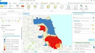
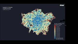
Transit Accessibility to Destinations

This video talks about how to calculate the transit accessibility to destinations. We show how you can do a comprehensive analysis of the level of public transit access in your city to important destinations, like jobs.
Download the slides for these presentations at https://esriurl.com/TransitVideoDownl.... Download Network Analyst tutorial data from https://links.esri.com/NetworkAnalyst....
Learn more about #Esri: Esri builds #ArcGIS, the leading location intelligence and spatial analytics software for mapping, 3D GIS, imagery and geospatial app development:
X: / esri
Instagram: / esrigram
LinkedIn: / esri
Facebook: / esrigis
Website: https://www.esri.com/


Recommended