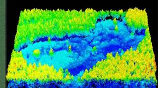
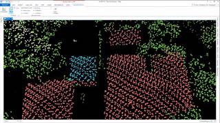
Tree canopy extraction in ArcGIS Pro

Welcome to my channel, dedicated to the fascinating worlds of space, remote sensing, and GIS. In today's video, I'm excited to present a comprehensive guide on the intricate process of tree canopy extraction using ArcGIS Pro. This procedure holds immense significance, especially within the mining industry and forest management applications. Additionally, precise tree canopy data plays a pivotal role in biomass estimation.
Traditionally, the extraction of canopy information involved using ENVI's crop science analysis tool or employing deep learning techniques within ArcGIS Pro. However, in this tutorial, we leverage the formidable capabilities of the Segmentation Mean Shift tool in ArcGIS Pro to segment our imagery. Following this, we create training samples and implement the Support Vector Machine classification technique to distinguish between canopy and noncanopy areas. Finally, we employ the Extract Attribute tool to derive the ultimate canopy area.
This video serves as a valuable resource for anyone seeking to master this crucial step in their geospatial analysis endeavors. I kindly request you to watch the video and share your valuable feedback. Don't forget to subscribe to my channel for more insightful content!