YouTube doesn't want you know this subscribers secret

Tree Heights from Lidar with QGIS (Create a Canopy Height Model)

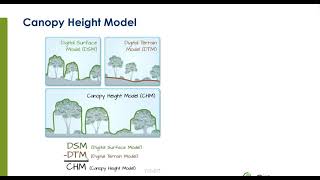
Create a canopy height model from lidar data in QGIS. Lidar makes it possible to calculate tree heights. This tutorial will demonstrate how to do this using the builtin QGIS tools.
Donate to Give Internet: https://giveinternet.org/opensourceop...
Website: https://geospatialschool.com


Recommended