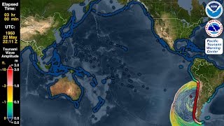
Tsunami Animation: Hawaii 1975

Not all tsunamis in the Hawaiian Islands come from overseas. On the early morning of November 29, 1975, a 7.7 magnitude* earthquake struck the southeast coast of the Big Island of Hawaii and generated a tsunami as high as 48 ft. (14.6 m). A 26 ft. (7.9 m) high wave killed two campers at the Halape Campground in Hawaii Volcanoes National Park. The tsunami also damaged property elsewhere on the Island of Hawaii and smaller nondestructive waves traveled as far as Alaska, California, Japan, and Samoa. For more information about this earthquake please see http://hvo.wr.usgs.gov/earthquakes/de...
Our animation shows how this tsunami may have propagated in the Hawaiian Islands, transitioning at its end first to an "energy map" showing the maximum wave heights over the 6hour period that the animation covers, then finishing with calculated tsunami runup heights on land. Note how the waves wrap around the islands and reach Honolulu in about 45 minutes. The campers in Halape, however, had only a few minutes to react, illustrating the most dangerous aspect of locally generated tsunamis: that people nearest to the tsunami source (earthquake, landslide, etc.) cannot wait for a siren to signal danger. If you are on or near a coastline and feel shaking so strong you cannot stand up, or shaking that lasts for a minute or more, leave the area as soon as the shaking stops and go to ground at least 50 ft. (15 m) above sea level. In Hawaii walking inland for about 20 minutes will usually do it, but you can see Hawaii's tsunami evacuation zones in your phone book or on this NOAA website: http://tsunami.csc.noaa.gov/map.html
*Nettles, M. and G. Ekström, "LongPeriod Source Characteristics of the 1975 Kalapana, Hawaii, Earthquake," Bulletin of the Seismological Society of America, 2004