Grow your YouTube channel like a PRO with a free tool

UAV Drone Aerial Image Processing with GCP for GIS Data Generation in Agisoft Metashape
UAV Drone Aerial Images Processing with GCP for GIS Data Generation in Agisoft Metashape.
in this lecture we will learn how to convert UAV images into variety of data including:
My Contact: [email protected]
3d point cloud
3d mesh generation
Aerial orthomosaic
Digital elevation model and more.
so we will see how to add and align photos in Agisoft Metashape,
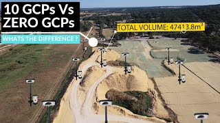
How to measure GCP points,
how to generate the dense cloud,
how to build DEM in agisoft metashape,
how to generate orthomosaic,
how to create 3d mesh,
how to add texture to the 3d mesh to enhance the clarity of terrain,
exporting data from agisoft metashape to GIS software,

![How to Download Digital Elevation Models (DEM) in QGIS [OPENTOPOGRAPHY]](https://i.ytimg.com/vi/FeM86Gz40_k/mqdefault.jpg)


Recommended