Understanding Marine Buoyage - 'quieter volume' - simple and easy www.coastalsafety.com
This version is "very quiet" on the volume so good for listening in an office environment for the full volume version go to • Understanding Marine Buoyage "quiet...
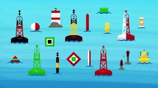
Buoyage is the general term that covers markers for indicating channel markers, safe water, danger areas and special purpose areas
Region A covers Europe and most of the of the world (red to port side).
Region B covers the America, Japan, the Philippines and South Korea (Green to port side).
Flash less light & more darkness
Long flash longer flash but still less light & more darkness
Isophase equal time of light and darkness
Occulting more light & less darkness
Navigation buoys fall into 6 types:
lateral marking channels
cardinal indicating safe direction of navigation
isolated danger small areas of danger
safe water safe navigation in all directions form the buoy
wrecks submerged and partially submerged ships wrecks and danger
special other areas where various activities are / are not allowed
Nautical chart symbols
Aids to Navigation that have lights are marked on the chart with a small teardrop shape that will be magenta in colour (easy to read under a RED night vision light). The teardrop can point in various directions to best display on the chart and the actual direction drawn on the chart is of no significance.
The exact location of the buoy or mark is the small circle or dot at the base symbol on the chart.
Lateral Marks are used generally to mark the sides of welldefined, navigable channels.
They are positioned in accordance with the "Conventional Direction of Buoyage" as discussed above.
They indicate the Port and Starboard hand sides of the route to be followed.
Generally, the bigger the buoy the bigger the vessels the channel is designed for / used by and so the deeper the water.
It may well be possible to navigate outside of the channel on a smaller boat depending on the height of tide and the nature of the sea bed.
Port and Starboard lateral marks tend to be can shaped on the port side and conical shaped on the starboard side this makes them easier to identify in low light or reduced visibility conditions.
Cardinal buoys and marks warn of danger and remain constant throughout the system of two IALA regions and are the same for areas IALA "A" and IALA "B" regions.
There may be only one buoy or more depending on the danger and the shape of the coast. For example, close to the shore they may be only one buoy as it may not be possible to go between the wreck and the shore.
The buoys have two black cones in different configurations which are know as the "top mark" cones these point to the black areas on the body of the buoy the rest of the buoy is yellow.
Your direction of approach doesn't matter – which makes them different from lateral buoys the buoys indicate where you should go.
The body of a cardinal buoy is always marked with a combination of black and yellow bands. It is always surmounted with a topmark consisting of 2 black triangles arranged in 1 of 4 combinations.
Cardinal Marks are used in conjunction with the compass to indicate the direction from the mark in which the deepest navigable water lies, to draw attention to a bend, junction or fork in a channel, or to mark the end of a shoal.
The buoys indicate where the safe water is, that is, mariners will be safe if they pass
North of a North mark
South of a South mark
East of an East mark
West of a West mark.
Isolated Danger Marks are used to mark small, isolated dangers with navigable water around the buoy
They are used to mark an isolated hazard in waters which otherwise are navigable. They are normally moored directly on or above the danger such as a large rock, shoal or sunken ship.
The pattern of bands is BLACK over RED over BLACK. The topmark is 2 BLACK balls. If lit, the light will show 2 WHITE flashes (Fl 2).
They can mark:
a small area of rocks
a pinnacle rock
small sand bank
old collapsed buildings in the sea
pipes that are a danger to surface navigation
Safe Water Marks may be used at the seaward end of the start of a channel to a port, midchannel, as a centreline markers or at the point where land is reached.
These buoys (as the name suggests) indicate the presence of safe, navigable water all around the buoy.
They may also indicate the best point of passage under a fixed bridge.
These buoys are coloured Red and White in vertical stripes.
It usually has a white light which flashes Isophase or Occulting or Morse code ‘A’
Emergency Wreck Buoys provide a clear and unambiguous means of marking new wrecks.
www.coastalsafety.com