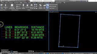
Unit Setup in AutoCAD to plot Distance Bearing in Surveying Coordinate System

In this video I have shown how to plot bearing and distance in AutoCAD.
There is two coordinate System.
One is Mathematical coordinate System and other one is Surveying Coordinate System.
In Mathematical coordinate System angle is computed from East line in anticlockwise manner.
Whereas in Surveying Coordinate System Bearing i.e. Angle is computed from North line towards clockwise direction.
By default AutoCAD is set with Mathematical coordinate System.
To use AutoCAD in Surveying system we have to change the UNIT setup in AutoCAD.
Watch this video to know more about unit setup in AutoCAD for Surveying Coordinate System.
If you like this tutorial then please give a LIKE and don't forget to SUBSCRIBE our channel for future videos.
Thank you.
Happy Learning.
Joyshree
for L&E