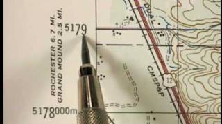
Universal Transverse Mercator coordinate system explained

The Universal Transverse Mercator (UTM) is a map projection system, or coordinate system, for assigning coordinates to locations on the surface of the Earth.
+++ Tales from the GIS?
Tales from the #GIS is a #geospatial journey into the fascinating world of Geographic Information Systems, telling you stories about nature and world.
+++Who am I?
Tales from the GIS is hosted by Eduard Roccatello. I love working on innovative solutions: things that change the status quo about spatial data development and usage. My day is full of math and big data. I like to be surrounded by interesting and skilled people. I really do care about user experience and software usability.
Music BenSound.com
#geospatialprogramming #dataviz #geospatialdevelopers #GIS #spatialdata