Unlocking Mining Insights: Landsat Indices for Mineral Exploration ⚒️⛏️

Unlocking Mining Insights: Landsat Indices for Mineral Exploration ⚒⛏
About this Video
Welcome to our channel, where we delve into the world of GIS, Remote Sensing, mineral exploration and mining using cuttingedge technology! In this video, we're taking you on a journey through the fascinating realm of Landsat satellite imagery and how it's being used to unlock crucial insights in the mining sector.
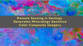
The mining industry is constantly seeking new ways to improve exploration and extraction techniques, and Landsat satellite data has emerged as a powerful tool to aid in this quest. We'll be exploring different indices derived from Landsat images that are instrumental in identifying key mineral resources, such as ferrous oxide, ferrous iron, ferrous silicate, laterite, and carbonate deposits.
Join us as we break down the science behind these Landsatderived indices and how they help mining professionals pinpoint valuable mineral deposits with a high degree of accuracy. We'll discuss their applications, the technology involved, and realworld case studies to demonstrate their effectiveness.
Whether you're a seasoned GIS expert or just curious about the technology driving mineral exploration, this video has something for everyone. Don't miss out on the opportunity to learn how Landsat indices are revolutionizing the way we approach mining, providing valuable data for sustainable and efficient resource extraction.
If you're interested in the future of mining, geospatial technology, or simply want to expand your knowledge in this field, hit that "Subscribe" button, give us a thumbs up, and be sure to leave your comments and questions below. We're excited to have you on this journey of discovery!
Stay tuned for more fascinating insights into the world of mineral exploration and the technologies shaping its future. Thanks for watching!
Chapters
00:00 Today's Topic
00:06 Study Location
00:27 Intro
00:33 Starting (General)
00:47 Ferric Oxide
01:40 Ferrous Iron
02:28 Ferrous Silicate
03:03 Laterite
03:30 Carbonate
04:16 Masking with shapefile
07:20 Outro
#mining #landsat #mineralexploration #GeospatialTechnology #satelliteimagery #ResourceExtraction #FerrousOxide #FerrousIron #FerrousSilicate #laterite #carbonate #MiningInsights ⚒⛏ #gis #remotesensing #dawnofgeospatialworld #tutorial
Playlists ⬇
1⃣ Various Space Agencies & Missions: https://bit.ly/44UBJQI
2⃣ Data Download Processes for GIS Work: https://bit.ly/44WYP9D
3⃣ QGIS Basics Tutorials: https://bit.ly/3Oljo95
4⃣ ArcMap Basics Tutorials: https://bit.ly/3DoAopy
5⃣ Terrain Analysis: https://bit.ly/44UBJ38
6⃣ Hydrological Analysis: https://bit.ly/472LGgY
7⃣ Image Classification: https://bit.ly/3sb1iyR
8⃣ Indices: https://bit.ly/3RfKPUB
The following geospatial and environmental solutions video instruction is available on this channel:
ArcGIS, QGIS (Geospatial Analysis, Monitoring)
Cartography
Basics of Mapmaking
Basics of GIS & Remote Sensing
You can watch our videos on YouTube : @dawnofgeospatialworld
If you think they're useful, kindly subscribe to our channel.
Instagram : / dogw_official
Facebook Group : / 1044628716532282
Thank you So Much.....