Sub4Sub network gives free YouTube subscribers

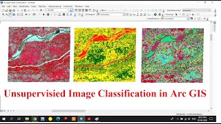
Unsupervised Classification of a satellite image using ArcGIS

In this tutorial you will learn how to:
1. Use Iso Cluster Unsupervised Classification tool
2. Reclassify a raster based on grouped values
3. Write a simple python script (If/ Else) to assign landcover types to the attributes table of ArcMap
⭐NOTE:
‘Kite’ is an excellent tool that can help you boost your productivity when it comes to programming with its free Artificial Intelligence (AI) powered coding assistant. Kite is a plugin which provides smart completions and documentation as you’re typingin your code, and its compatible with most of the wellknown IDEs such as PyCharm, Spyder and VS Code. I absolutely love it, and recommend you guys to try it out as well.
https://www.kite.com/getkite/?utm_me...


Recommended