Using LiDAR to Locate Areas of Placer Gold Deposition

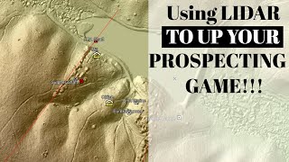
In this one I go over a feature within SAGA GIS called the Stream Power Index, which calculates the areas of waterways that are more likely to undergo erosion or deposition. With it you can determine which areas you want to focus on in the field before heading out. Both areas of deposition and erosion are sought after by the gold prospector. The areas of high erosion will be more likely to hold exposed bedrock for you to snipe and crevice, while the areas of deposition may be more prone to holding largerscale placer gold deposits and material for you to work.
Your time in the field is precious, so you should use as many tools as possible before getting to the field to maximize your time spent digging those potential hot spots.
Video on downloading SAGA GIS: • Make your own Lidar maps for gold pro...
SAGA GIS Download: https://sourceforge.net/projects/saga...
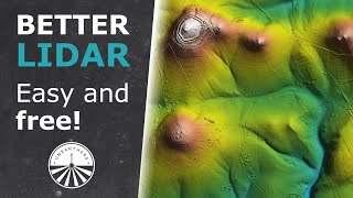
Location to get LiDAR DEM files: https://apps.nationalmap.gov/downloader/