Free YouTube views likes and subscribers? Easily!

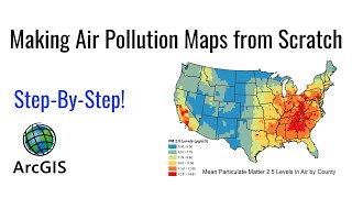
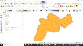
Using QGIS to Interpolate Air Pollution Sampling Points using IDW
This video tutorial shows how to create an Inverse Distance Weighted (IDW) interpolated raster from a spreadsheet file containing sampled points dispersed around N.W England in the UK. It uses QGIS and shows how to generate a final map complete with Legend, Title, Scalebar and North arrow. QGIS can be downloaded here (https://qgis.org/en/site/). The country SHAPE file of the UK (or any other country) can be downloaded here (http://www.divagis.org/gdata). The spreadsheet containing the sample data for this exercise can be downloaded here (http://www.ukscience.org/NumParticles....


Recommended