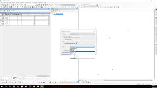
( UTM Grid / Decimal Degrees ) to Latitude Longitude using Arc GIS

#utmgrid#DecimalDegree#LatitudeLongtitude#arcgis
Welcome to Remote Sensing GIS Home. In this tutorial, we have learned how to convert UTM Grid or Decimal Degrees point data to latitude longitude in (degree minute second ) formate.
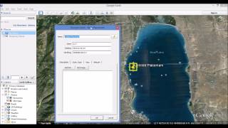
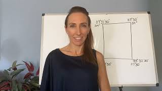
A Universal Transverse Mercator coordinate comprises a zone number, a hemisphere (N/S), easting, and northing. Eastings are referenced from the central meridian of each zone, & northings from the equator, both in meters.
======Contents of this video======
00:00 introduction
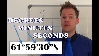
00:53 Decimal Degrees to degree minute second
03:58 UTM Grid to degree minute second
06:10 Export the data in ms excel
Join our Free Telegram Channel:
https://t.me/rsgishome
RS GIS HOME Facebook Page:
/ rsgishome
RS GIS HOME Facebook Groups:
/ geospatialcommunity
Follow me on Linkedin:
/ santanughosh7714b3141
===========================================================================
Playlists:
Geomatics Engineering Gate 2022 || Free Course:
• Geomatics Engineering Gate 2022 || Fr...
Remote Sensing and GIS tutorial:
• Remote Sensing and GIS tutorial.
ArcGIS for beginners:
• Arcgis for beginners.
ArcGIS Model Builder:
• ArcGIS Model Builder
Excel to ArcMap:
• Excel to ArcMap
Google Earth Pro:
• Google Earth Pro
DGPS :
• DGPS
Satellite Data Download:
• Satellite Data Download
_______________________________________________________________________________
Welcome to the Remote Sensing GIS Home YouTube channel, we hope you like our videos.
Subscribe to our channel for the latest Videos and Lectures on Geomatic Engineering.
___________________________________________________________________________________
About the Channel:
On this YouTube Channel:
Knowledge of Remote Sensing and GIS and how it works in the world
Videos and Lectures on Remote Sensing and GIS Techniques and their applications
A brief explanation of Practical Portion of GIS & Remote Sensing
Boost your concept with Remote Sensing and GIS
Keep yourself updated with the new techniques of Remote Sensing and GIS field
Onestop platform for Remote Sensing and GIS
Video Lectures & Study Material in Geomatics Engineering(GE for GATE)
So stay connected with us by just clicking on the Red Subscribe button and pressing the bell icon.
___________________________________________________________________________________
Reference
Introduction to Geographic Information Systems by KangTsung Chang
Disclaimer
The presentation has been compiled from various sources such as books, tutorials (online and offline), internet. The information in this lecture /presentation is for general information and education purposes.
Thank You.


![Basic GIS # 17 | Geographic Coordinate System vs Projected Coordinate System [Urdu/ Hindi]](https://i.ytimg.com/vi/9YpUmQ-pxyo/mqdefault.jpg)