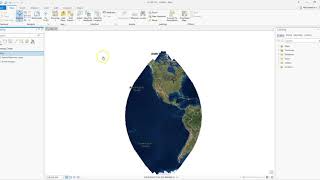
Viewing and Changing Projection Information in ArcGIS Pro
A projection is the method by which a 3D object such as a state or realworld area is placed onto a 2D flat surface such as a map. No matter what method, there will always be some type of distortion. In addition, projections work to minimize the distortion for a particular area. For example, the North Carolina State Plane projection, while displaying some directional/azimuthal distortion, minimized distortion for geospatial data shown in North Carolina. That is not to say the minimization of this distortion does not exist when displaying data from other parts of the country using this projection when another projection may work better. This tutorial discussion how to change projection information and all of the numbers/information that go into projections.