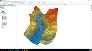
Visualizing 3D DEM Data in ArcScene: A Step-by-Step Tutorial

The video titled "Visualizing 3D DEM Data in ArcScene: A StepbyStep Tutorial" is a tutorial that provides a detailed guide on how to visualize threedimensional (3D) digital elevation model (DEM) data using ArcScene, a software tool provided by Esri. The video explains what DEM data is and how it can be used in various applications such as terrain analysis, hydrology, and urban planning. The tutorial then proceeds to demonstrate the process of importing DEM data into ArcScene and creating a 3D scene using the software's various features and tools. The video covers topics such as data manipulation, symbolization, terrain analysis, and visualization techniques, providing a comprehensive guide on how to work with 3D DEM data in ArcScene. The tutorial aims to help GIS professionals, students, and anyone interested in geospatial analysis to visualize and analyze 3D DEM data in a simple and effective way.
__________
Check it out:
Like & Share the video with others:
✅ • Visualizing 3D DEM Data in ArcScene: ...
_ _ _ _ _ _ _ _ _ _ _ _ _ _ _ _ _ _ _ _ _ _
Subscribe to our channel :
✅ / @rsgis6997
=========================================================
#gis #gistutorial #remotesensing #rsandgis #arcgis