Sign In
Home
Popular
News
Popular now
New music
Cute animals
Trending today
Hot trailers
Popular music
Comedy clips
New tech
Popular sports
Learn new
The easiest way to skyrocket your YouTube subscribers
Animals
Babies
Beautiful
Cats
Creative
Cute
Dogs
Educational
Funny
Heartwarming
Holidays
Incredible
Inspirational
Interesting
Love
Music
Nature
Oops
Performance
Pranks
Science
Sports
Technology
Unexpected
Cat Videos
Puppy Humor
Cover Song Competition
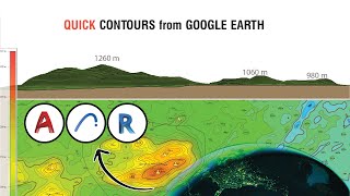
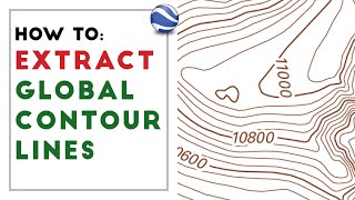
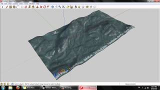
Visualizing Contour (Topographic) Maps In Google Earth
Back
Follow
A tour through a few locations in google earth to show how contours represent 3D.
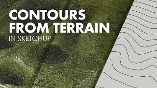
posted by
trassar1l
[ f ] Share this video on Facebook
Introduction to Topographic Maps
How to Create 3D Terrain with Google Maps and Blender!
Generate Easily Google Earth Contours to AutoCAD RevitArchiCAD
How To Read a Topographic Map
How to extract contour lines And DEM from Google Earth
How to Generate A Contour Map with Sketchup
How to extract contour lines from Google Earth To Autocad
How to Import LiDAR Data into Google Earth
How to Download Topographic Maps using Google Earth Pro
How to extract CONTOUR LINES from anywhere in the world!
extract contour lines from Google Earth
How to create a CINEMATIC VIDEO using GOOGLE EARTH STUDIO
How to contour (topographic maps)
Downloading Topographic Maps using Google Earth
Visualizing Topographic Contours in Google Earth
Topography from Google Earth
Understanding Contour Lines
How to visualize topographical map in Google Earth | Overlay map on Google Eath
QGIS Georeferencing Google Earth Images
The easiest way to EXTRACT CONTOURS from GOOGLE EARTH directly in AUTOCAD using GLOBAL MAPPER
Recommended
Fresh Snow Makes Blid Dog Cheer Up!
00:52
Hypnotizing Domino Trick
03:54
9 Must Know Scientific Study Hacks
03:26
Easy Ways To Make Your Work Day Pass Faster
01:05
LA vs NY Kids Stand For Their Cities... Mentally!
03:27
Baku Welcomes Sportsmen & Dancers!
02:49
Magic Tricks To Speed Up Your Brain
05:28
Crash Of Cranes - Truly Hilarious Prank!
02:10