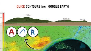
Visualizing Topographic Contours in Google Earth

In this tutorial, you will learn how to visualize topographic contours over a 3D terrain using Google Earth. We will be downloading the SRTM digital elevation data in raster format from USGS EarthExplorer web portal, and using QGIS we will generate the contour lines which is then exported to .kml file format.
We can use Google Earth application open the .kml file and visualize these contours on a 3D terrain.
You may also check out the following videos that are related to this tutorial:
Google Earth Pro A Complete Beginner’s Guide • Google Earth Pro A Complete Beginne...
Google Earth Pro Advanced Tutorial (Part 1) • Google Earth Pro Advanced Tutorial (P...
Google Earth Pro Advanced Tutorial (Part 2) • Google Earth Pro Advanced Tutorial (P...
#googleearth #3dmaps #geodeltalabs