Easy way to get 15 free YouTube views, likes and subscribers

VOIRIES/Part2: CREATE A POLYLINE SHAPEFILE FOR ROADS إنشاء الطرقات في شكل خطوط

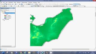
درس تطبيقي للمبتدئين حول كيفية رسم شايبفايل شبكة الطرقات داخل المدينة باستخدام الآركجيس
00:00 INTRODUCTION
02:45 DEMONSTRATION
04:35 Create shapefile
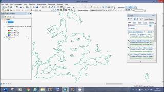
05:58 Start editing
07:18 Snapping
08:25 Draw roads
08:59 Add a field to the attribute table and enter the name of the road
12:27 Edit and Merge lines
15:46 Split a line
16:47 Draw circle
18:57 Add labels to the map
19:50 Change shapefile name
20:46 Enter road types in attribute table
21:28 Field calculator
25:50 Enter road classes
Create a High Resolution Raster إعداد تغطية القمر الصناعي لمنطقة الدراسة بجودة عالية : • Create a High Resolution Raster إعداد...
VOIRIES/Part1: ATTRIBUTE TABLE جدول سمات شبكة الطرقات : • VOIRIES/Part1: ATTRIBUTE TABLE جدول س...


![HandsOn Power BI Tutorial Beginner to Pro [Full Course] ⚡](https://i.ytimg.com/vi/5X5LWcLtkzg/mqdefault.jpg)
![Data Modeling for Power BI [Full Course]](https://i.ytimg.com/vi/MrLnibFTtbA/mqdefault.jpg)

Recommended