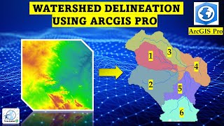
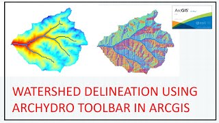
Watershed delineation in arcgis | stream order extraction

watershed delineation
Absolutely! Here's a detailed description for watershed, watershed extraction, watershed delineation, catchment extraction, stream order mapping, and water channel mapping in ArcGIS:
" Welcome here, where we embark on a geospatial journey through the intricate world of watershed analysis in ArcGIS! In this tutorial, we'll demystify the processes of watershed extraction, delineation, catchment extraction, stream order mapping, and water channel mapping, equipping you with the skills to master hydrological analysis.
Key Topics Explored:
Watershed Extraction: Learn how to precisely define and extract watersheds, understanding the intricate boundaries that shape these essential hydrological features.
Watershed Delineation: Delve into the art and science of delineating watersheds, exploring the tools and techniques within ArcGIS for accurate representation.
Catchment Extraction: Uncover the secrets of catchment extraction, ensuring a comprehensive understanding of the contributing areas within a landscape.
Stream Order Mapping: Navigate through the steps of stream order mapping, a crucial aspect of hydrological analysis that categorizes streams based on their hierarchy within a river network.
Water Channel Mapping: Explore the methods to map water channels, gaining insights into the dynamic flow paths that shape the landscape.
Why Mastering these Techniques Matters:
These skills aren't just for GIS professionals; they're for anyone passionate about environmental management, water resource planning, and spatial analysis. Whether you're a seasoned pro or just starting your GIS journey, this tutorial provides a detailed roadmap to elevate your mapping game.
HandsOn Learning:
Follow along with our stepbystep guide, as we demonstrate practical applications and provide insider tips to ensure accurate and insightful hydrological analysis in ArcGIS.
Watershed Delineation Tools:
*Fill (Spatial Analyst): Fills sinks or low points in a raster, preparing the elevation data for further analysis.
https://pro.arcgis.com/en/proapp/lat....
*Flow Direction (Spatial Analyst): Determines the direction of flow for each cell in a raster, indicating how water would flow downhill.
https://pro.arcgis.com/en/proapp/lat...
*Flow Accumulation (Spatial Analyst): Calculates the accumulated flow into each cell, helping identify areas with high water flow and potential watershed boundaries.
https://pro.arcgis.com/en/proapp/lat...
*Watershed (Spatial Analyst): Defines the contributing area for each cell by delineating watershed boundaries based on flow direction and accumulation.
https://pro.arcgis.com/en/proapp/lat...
*Stream Order Mapping Tools:
Stream Link (Spatial Analyst): Identifies the continuous network of streams by assigning unique values to stream cells.
https://pro.arcgis.com/en/proapp/lat...
*Stream to Feature (Spatial Analyst): Converts a raster stream network into a vector feature class, allowing for easier mapping and analysis.
*Stream Order (Spatial Analyst): Assigns stream order values to each segment of the stream network based on the Strahler stream order system.
*Stream Order and Wearing Index (Spatial Analyst): A tool that calculates both stream order and the Wearing Index, providing additional information about the stream network.
*Snap Pour Point (Spatial Analyst): Adjusts the location of pour points (outlets) to the nearest cell with a defined flow direction, improving accuracy in watershed delineation.
Engage with the Community:
Like what you see? Hit the like button! Subscribe to [Your Channel Name] for more indepth GIS insights. Don't forget to ring the notification bell to stay updated on our upcoming tutorials.
#ArcGIS
#GISAnalysis
#Hydrology
#WatershedMapping
#StreamOrder
#SpatialAnalysis
#Geospatial
#WaterResourceManagement
#EnvironmentalMapping
#GISCommunity
#MappingSkills
#DataVisualization
#RemoteSensing
#EarthObservation
#GISTutorial
#CatchmentAnalysis
#FlowDirection
#GISEducation
#WaterChannelMapping
#cartography
#catchmentarea