Grow your YouTube channel like a PRO with a free tool

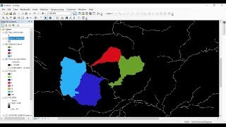
Watershed Delineation in QGIS (Quickest u0026 Easiest Tutorial)
This tutorial will describe the shortest & easiest method to delineate watershed in QGIS.
You just need a DEM (Digital Elevation Model) of desired area and a reference base map like Google map of Google Earth Images
Tutorial to download SRTM DEM in QGIS through SRTM Downloader plugin
• Download SRTM DEM in QGIS
Tutorial to add Google Images and Maps in QGIS through HCMGIS plugin
• Google Earth Images in QGIS


Recommended