Webinar: Introduction to Geospatial Analysis in R

Short Description: During this webinar we will provide an overview of common geospatial operations in R including: how to import data files into R, overlay layers, reduce spatial extent, select and reclassify values, and make a map.
Detailed Description:
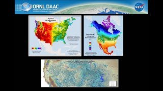
The opensource software environment R is gaining popularity among many scientists, including geologists, biologists, and environmental scientists. R provides an alternative to traditional GIS software with numerous packages for geospatial analysis. This webinar will begin with a brief introduction to an example geospatial dataset from the ORNL DAAC and an overview of common geospatial operations in R. Next, we will demonstrate how to import files into R, overlay layers, reduce spatial extent, select and reclassify values, and make a map.