Why does it rain?
Full text:
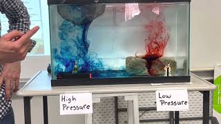
In the previous video you already saw how water vapor condenses at a high relative humidity. This video explains the formation of clouds.
For clouds to form, the air must first cool down so that the water vapor can condense. The air cools when it gets higher in the atmosphere because it is colder there. But, there are 3 ways for air to get higher in the atmosphere.
1) The first cause of cooling air is rise due to the heating of air. When air is heated, it expands. This makes the air relatively lighter than the surrounding air, and rises higher in the atmosphere where it is colder. The water vapor in the air condenses, creating clouds. This form of cloud formation plays an important role especially around the equator.
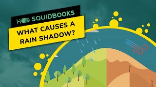
The second is orographic lift. The wind blowing over a surface may collide with a hill or mountain along the way. As a result, the air must rise. Because the air has to rise, the air cools and the water vapor can condense. This causes it to rain. By the time the air is on top of the mountain, all the water vapor has condensed. As the air descends on the other side of the mountain, it moves closer to the Earth's surface and thus the air will warm up.
As a result, no condensation takes place and it will therefore generally be dry and sunny. This area lies in the rain shadow, which is so called because it rains little here. This side is called the leeward side. The side where it rains a lot is called the windward side. In many mountain ranges where the wind mainly comes from the same direction, there is enough vegetation on the windward side, because there is enough precipitation.
On the lee side is often a desert area. Examples are the areas in the rain shadow of the Andes or the Himalayas. However, you don't necessarily need mountains for this effect. The Veluwe is one of the wettest places in the Netherlands, because it is several tens to a hundred meters higher, so that clouds and eventually precipitation are created here as well.
The last way for air to rise is by colliding with another layer of air. Around latitudes 50 and 60, warm air from the south and cold air from the north often collide. These layers of air do not mix and the heaviest layer of air will dive below the lighter layer of air. The cold air from the north is the heaviest air layer, and the warmer air from the south is the lighter air layer. This warm, lighter layer of air will therefore rise. This cools the air, condenses the water vapor and creates clouds and eventually precipitation. Especially clouds at higher latitudes are formed in this way.
Now you know the three ways clouds and precipitation are formed.