Working with Points in GIS

Detailed tutorial on working with point features in GIS!
In this video, we cover everything you need to know to effectively manage and analyze point data.
Our video includes:
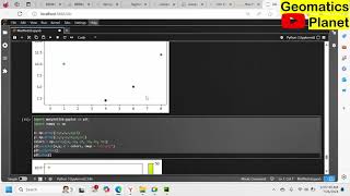
Creating Point Features from GPS Data: Learn how to import GPS data into your GIS software and convert it into point features for further analysis.
Editing Point Attributes and Locations: Master the techniques for modifying the attributes and locations of your point features to ensure accuracy and relevance.
Visualizing and Analyzing Points by Attributes: Discover how to visualize your point data based on different attributes, such as states or categories, to uncover patterns and insights.
Creating Point Density Maps:
Find out how to create point density maps to represent the concentration of points within a given area, enhancing your spatial analysis.
Whether you're a beginner or looking to refine your GIS skills, this comprehensive guide will equip you with the tools and knowledge to work with point data effectively.
Don't forget to like, comment, and subscribe for more GIS tutorials!