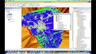
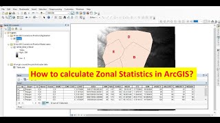
Zonal statistics: How to extract data for each subbasin in ArcMap

After estimation of the soil loss in the watershed this tools is for extraction soil loss in each subbasin in the watershed
Other links:
#How to calculate LS FACTOR for USLE/RUSLE in ArcMap
• How to calculate LS FACTOR for USLE/R...
#How to Calculate the landuse/landcover surface in ArcMap
• How to Calculate the landuse/landcove...
#Water Stream/Drainage Line Extraction From DEM in ArcMap
• How to extract River shape from DEM I...
#Kriging vs Inverse distance weighted (IDW)
• Kriging vs Inverse distance weighted ...
#ArcGis: How to make a Geostatistical Analysis in ArcMap
• Kriging vs Inverse distance weighted ...
#How to Make a Map in ArcMap/ArcGis
• How to Make a Map in ArcMap/ArcGis
#ArcGis: Watershed/Basin Delineation in ArcMap using ArcHydro tools and DEM
• ArcGis: Watershed/Basin Delineation i...
#Envi: Soil Classification and Validation with Confusion matrix
/ jaswe0g4r
#Radiometric and Atmospheric Correction in Envi
• Radiometric and Atmospheric Correcti...
#ArcGis: How to Georeference a Degital Elevation Model automatically in ArcMap
• How to Georeference a Degital Elevat...
Facebook : / educpsy100872484841434
Instagram : / educpsy